BRAZILIAN NAVY
HYDROGRAPHIC CENTRE OF THE NAVY
THE DIGILEVEL
Author: Lieutenant Commander Marcelo Fricks Cavalcante
Address: Rua Barão de Jaceguay, s/nº Ponta da Armação – Niterói – RJ- Brasil, CEP 24.048-900
Phone: (55 – 21) 2613-8261, Fax: (55 – 21) 2613-8226
e-mail: 112@chm.mar.mil.br or mfcavalcante@hotmail.com
Last review: September 11th 2003.
Introduction
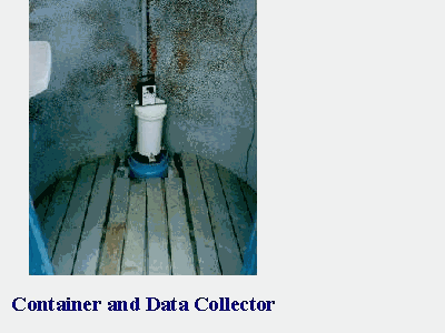
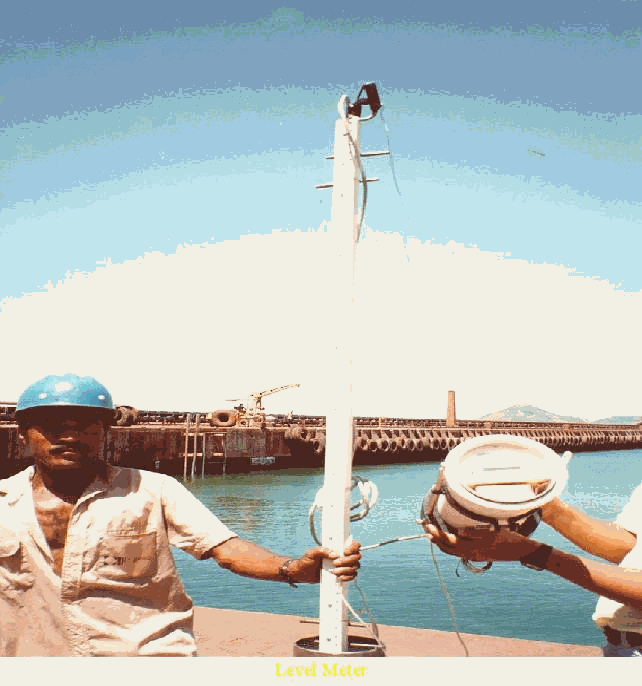
The objective of this work is to introduce a new technology on sea level measurements. In order to follow the GLOSS standards regarding data acquisition and processing, a digital system, called DIGILEVEL, was developed in the 90’s, in Brasil, by the Oceanic Instrumentation Laboratory, from COPPE – UFRJ. It resembles an electronic tide staff with sensors spaced 1 cm apart along a staff that is housed in the stilling well (Figure 1).
A general description of this system is provided in section 2, while section 3 describes the methodology used to evaluate the DIGILEVEL performance on recording sea level data, according to the GLOSS standards. Section 4 gives a summary and some recommendations for future work.
Figure 1: Level Meter
Sensor Characteristics
(Contact person: Mr. Luiz Falcão, e-mail: luizfalcao@terra.com.br )
The main utility of the DIGILEVEL is the measurement of the water level in the ocean, lakes, rivers, dams and other water bodies. It is compatible with different types of equipments like graduated rulers, buoy limnigraphs and pressure tide meters among others. A function diagram of this system is shown in Figure 2.
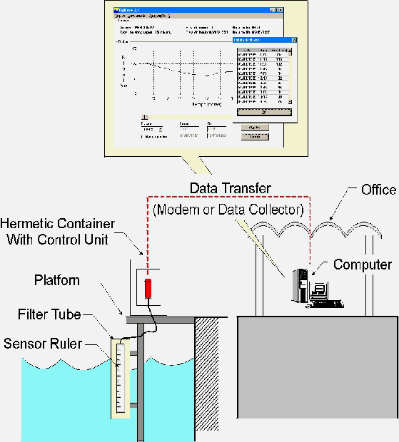
Figure 2: DIGILEVEL Function Diagram
The major advantages of this system consists on:
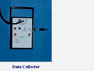
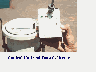
Figure 3 shows some components of the DIGILEVEL system, like the control unit, the container and the data collector. The general sensor characteristics are listed below:
SENSOR RULER
Resolution : 1 cm
Length : N x 1,28 m
Electrodes : Stainless Steel
Structure : Stainless steel and Epoxy Resin
CONTROL UNIT
Sample Rate : 1 minute to 6 hours
Storage Capacity: 32.000 samples
Display : LCD (2 lines x 16 characters)
Interfaces : Serial RS-232
Modem 2400 bps (optional)
Battery Life : 2 months
Electrical Power (optional)
Setup : Date, Hour and Sample Rate
DATA COLLECTOR
Storage Capacity : 32.000 samples
Indications : Power On
Communication Error
Interface : Serial RS-232
Battery Life : 5 days
|
|
|
| Figure 3: DIGILEVEL components | ||
Nowadays electronic readings are made at 15-minute intervals. The data are buffered into a data collection platform (DCP) in the tide station protective house. The DCP can be interrogated by telephone to directly download the data at the user’s processing station. This operation is typically performed daily with the DCP buffer size well over a month. Data collected can be downloaded in a PC, by using a windows interface program, as shown in Figure 4.
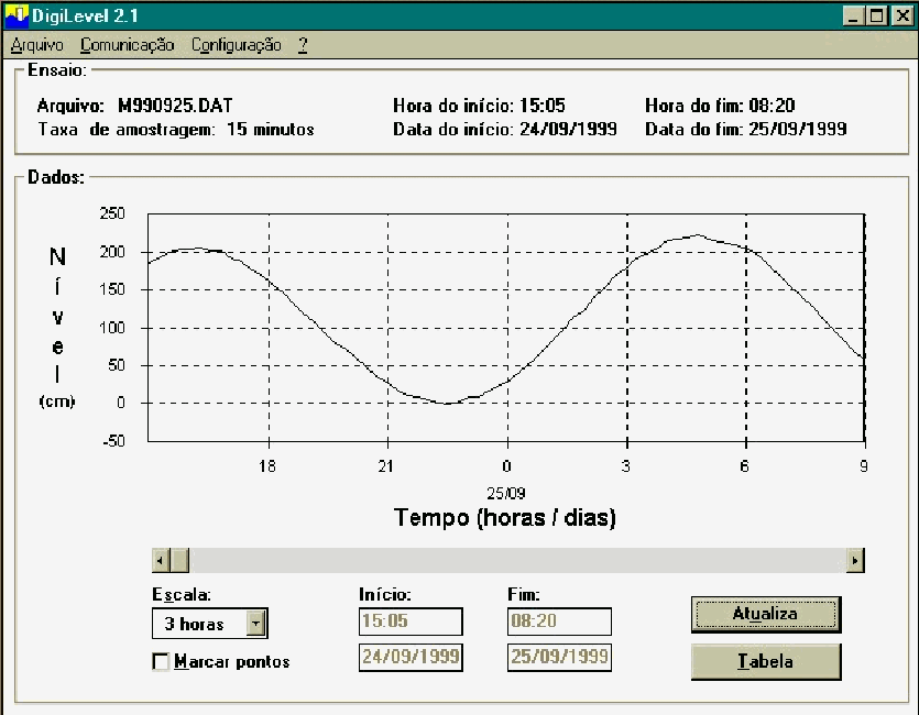
Figure 4: Software presentation
3.0 System Evaluation
(Contact person: LTCdr. Marcelo Fricks Cavalcante, e-mail: 112@chm.mar.mil.br )
To evaluate DIGILEVEL data quality, regarding GLOSS standards, a study has been carried out by CHM. The methodology basically consists on time series comparisons between DIGILEVEL and an analog equipment (a float gauge). During the last four months some changes have been made on the DIGILEVEL system and considerable improvement can be noticed, as shown in Figure 5.
Figure 5 a) shows sea level data at Ponta da Armação site (the place where DHN is located) during May 2003. A lot of discrepancies can be noticed between the two time series. Most of the disagreements could be related with phase’s differences (mostly on period between May 1st and 12th). On the period between May 12th and 17th some large differences, now at the lower levels (when the sea level drops bellow 150 cm) can be noticed. The same situation remained on June.
On the beginning of July, the clock sensor of this system was replaced by a different one, in an attempt to solve the above mentioned phase’s discrepancies. It’s clearly noticeable the improvement on the agreement between both series, but there are still some large differences at the lower levels, as also occurred on May. It was found that these differences were due to some incrustations on the DIGILEVEL staff, which had all its underwater components completely cleaned on July 28.
Time series comparisons on August (Figure 5c)), indicates a more stable situation, where the differences are, in general, bellow 10 cm in amplitude (Figure 6) and the monthly means of the two sensors were found to differ by only one centimeter, where the DIGILEVEL was greater than the Conventional. Since the two time series are presenting very similar behavior, not only in phase but also in amplitudes, it’s difficult to assume that all the discrepancies occurred between both series are exclusively related to the DIGILEVEL.
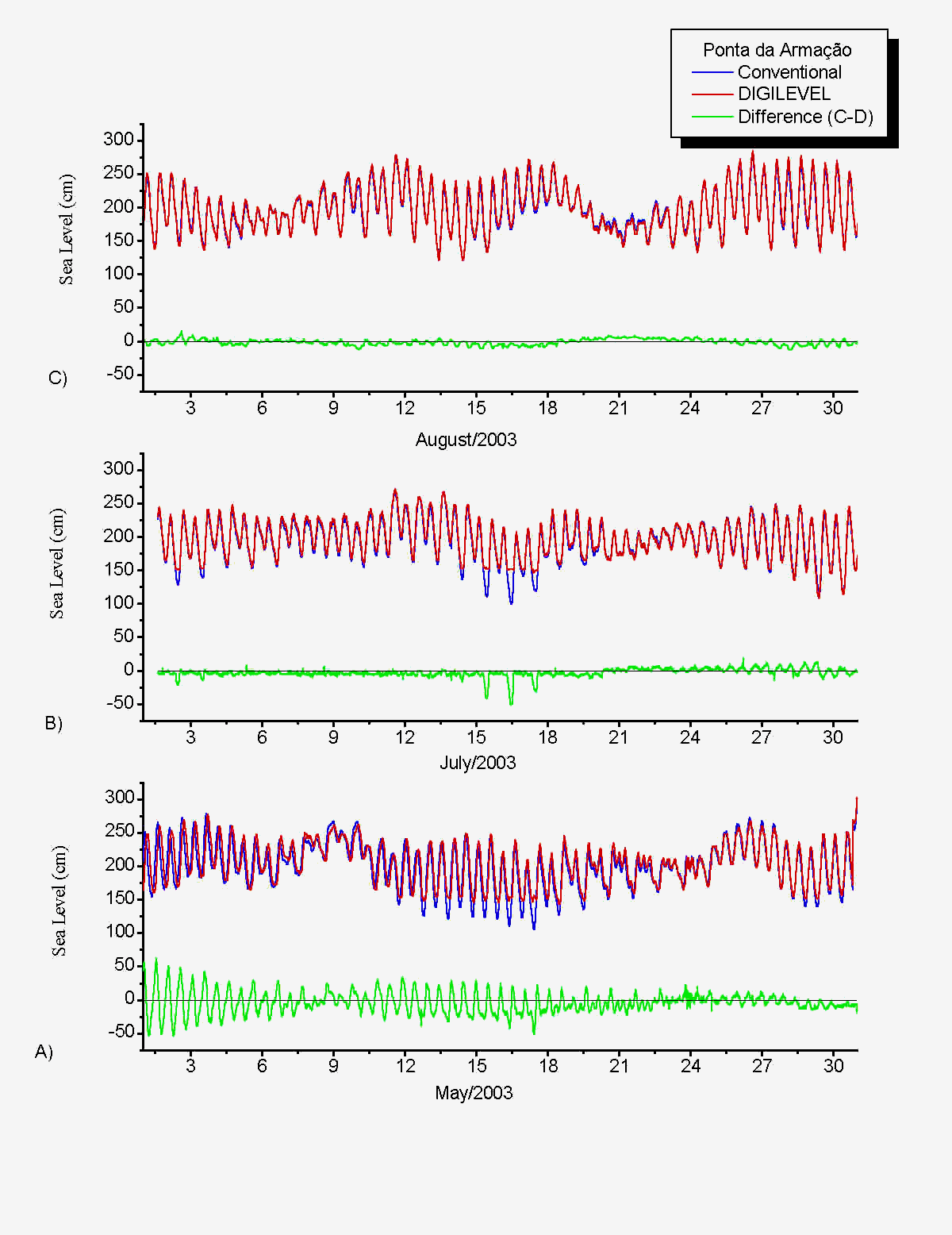 |
| Figure 5: Time Series Comparisons Between raw data obtained with the DIGILEVEL (red) and with an Analog Tide gauge (blue), at Ponta da Armação, during May (a), July (b) and August (c) 2003. The time series differences are shown in green (Conventional – Digital). |
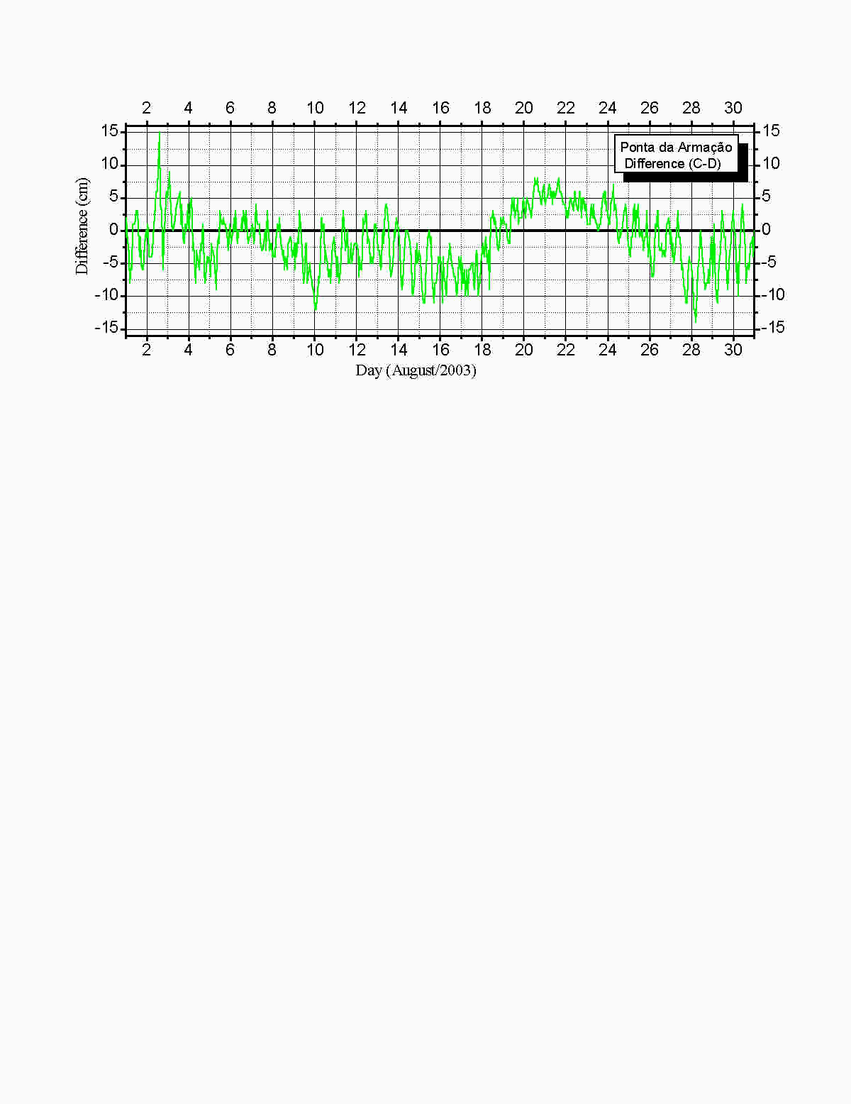 |
| Figure 6: Time Series Difference of raw data obtained with the DIGILEVEL and with an Analog Tide gauge, at Ponta da Armação, during August 2003. |
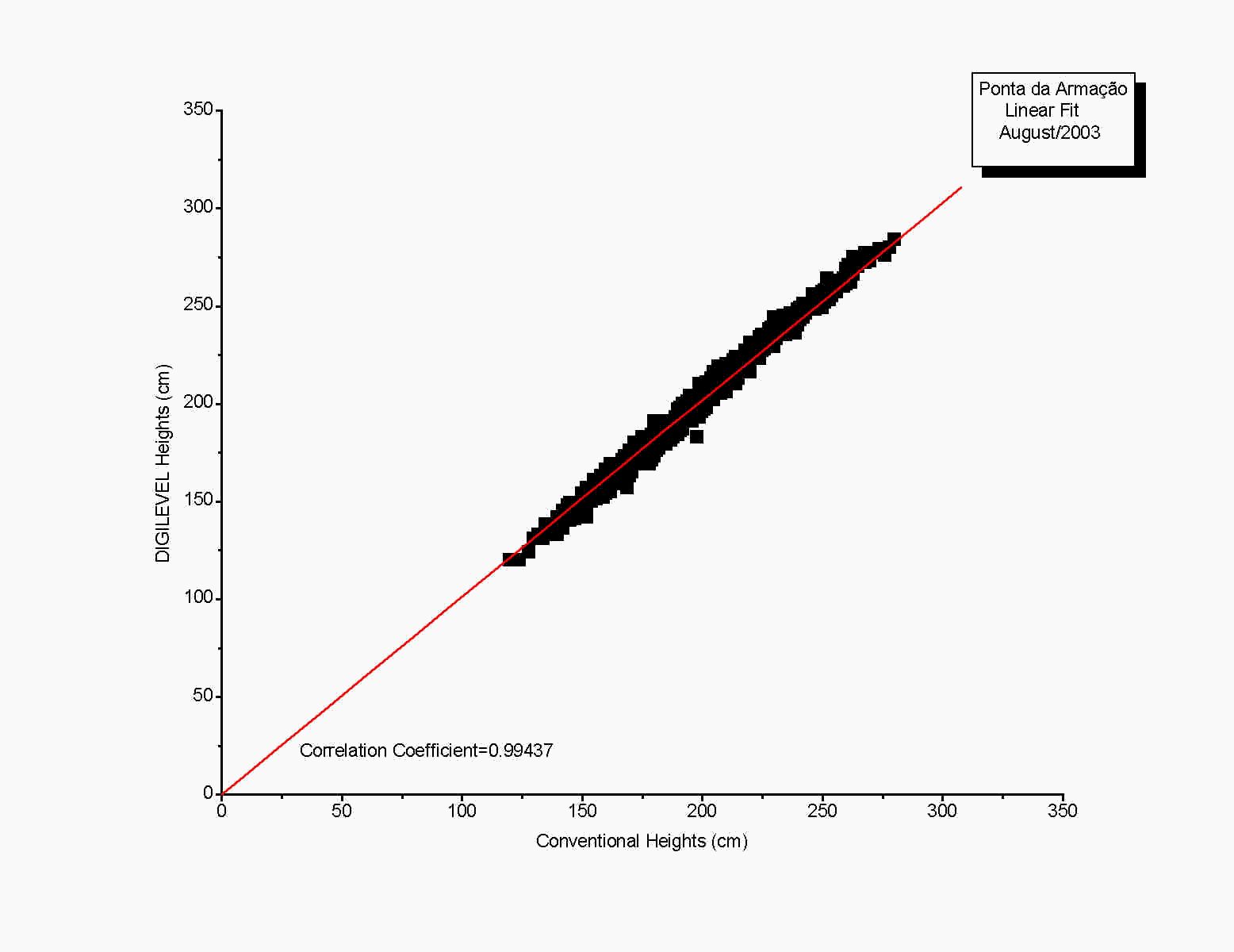
Statistics between both time series indicated a Correlation Coefficient of 0.99437, with Standard Deviation of 4.26651, for 744 points. The plotting of the linear fit is shown in Figure 7.
|
| Figure 7: Scatter plot of sea level heights (cm) obtained with the Conventional and the Digital tide gauges during August 2003 at Ponta da Armação. The linear fitting line is shown in red. |
The above mentioned results are very encouraging and indicate that this evaluation work should continue in order to better understand the reason of the differences shown in Figure 7, but also points out that the one centimeter difference between both time series of raw data, is a very reasonable value considering the GLOSS standards.
4.0 Summary and Future Work
The DIGILEVEL system was introduced, and its performance has been evaluated. The system, considering it’s simplicity and also the quality of data recorded, can be assumed as a promising option to be used on sea level measurements. The evaluation process will continue in order to verify the reliability and confidence of the system.
The implementations, recently done, indicated some upgrade of the system performance. For example, the change of the clock sensor as well as the implementation of a routinely maintenance showed some improvement of the DIGILEVEL data quality when compared with the analog one. The differences between both time series were found, in general, to be below 10 cm, with monthly means of raw data differing only one centimeter. At this point, another tide gauge should be installed, in order to provide a third information to complement the evaluation process, since now the differences are low, and the DIGILEVEL can not be blamed for all errors of measurements. The evaluation process will continue in order to verify the reliability and confidence of the system
Acknowledgments: to Rafael Guarino Soutelino for the help during the DIGILEVEL evaluations.